FieldInspect is the all in one field inspection assistant for engineers, environmental professionals, marina operators, inspectors, and consultants
FieldInspect is the all in one field inspection assistant for engineers, environmental professionals, marina operators, inspectors, and consultants.

Capture site observations, document infrastructure conditions, record GPS locations, generate reports, and identify potential permitting requirements directly from the field.

Key Features:

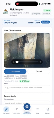
Photo Based Inspections

Capture and organize site photos
Document damage, deficiencies, and observations
Attach notes and inspection details

GPS Location & Path Recording

Record observation locations
Capture inspection routes and site walks
Track field activities with georeferenced data

AI Assisted Analysis

Identify potential damage types
Generate observation summaries
Provide inspection insights and recommendations

Professional Reporting

Create branded inspection reports
Export project documentation
Share findings with clients and stakeholders

Infrastructure Assessments

Seawalls
Bulkheads
Docks and marinas
Bridges
Coastal structures
Environmental sites
General civil infrastructure

Permit Intelligence

Review potential permitting requirements
Identify likely agencies and jurisdictions
Streamline project planning
Ideal For
Coastal Engineers
Civil Engineers
Environmental Consultants
Construction Inspectors
Marina Operators
Facility Managers
Government Agencies
Infrastructure Owners

Disclaimer: AI generated insights are provided for informational purposes only and should be reviewed by qualified professionals.