
GeoMerge
0.0 541.00KB 0 Free
Version 1.0.1
Updated 2026-07-29
Developer Jeunghyun BYUN

Description
Your camera takes beautiful photos — but without GPS, they never show up on the map
Your camera takes beautiful photos — but without GPS, they never show up on the map.

GeoMerge fixes that. Record a GPX track with any tracking app while you shoot, then let GeoMerge match each photo to where you were at that moment.

HOW IT WORKS
1. Import a GPX track (or share one straight from your tracking app).
2. Tap "Find photos" — GeoMerge automatically pulls in the photos taken during that track.
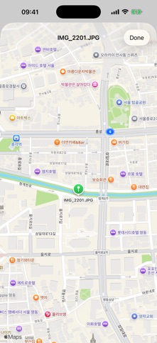
3. Check the match: every photo gets a Map pin preview before anything is written.
4. Tag — GPS coordinates are written to the photos in your library.

FEATURES
• Automatic photo selection from the track's time range
• Precise position by interpolating between track points
• Photos and videos — geotag both
• Map preview for every match — verify before you write
• Skips items that already have GPS (e.g. your iPhone shots) — never overwrites them
• Time offset with auto-estimation, for cameras set to another timezone or drifting clocks
• ±3 min tolerance absorbs small clock errors automatically
• Works with GPX from any app: Open GPX Tracker, Strava, Garmin, and more

PRIVATE BY DESIGN
Everything happens on your device. No account, no server, no analytics, no data collection — your photos and tracks never leave your phone.

Made for photographers who love their dedicated camera but miss the map.
Category: Photo & Video(28122)
Version: 1.0.1
BundleId: com.neoul.GeoMerge
Developer: Jeunghyun BYUN
Updated: 2026-07-29
