



Description
Every drone weather app shows you numbers
Every drone weather app shows you numbers. UAV Drone Forecast gives you the answer.

GO / CAUTION / NO-GO — one verdict, computed for YOUR drone. Pick from 32 models (DJI Mini, Air, Mavic, Avata, Inspire, Matrice and more) and the safety limits come from the manufacturer's real wind rating, not a generic guess. A Mini 2 and a Matrice 350 do not fly in the same weather, and this app knows it.

WHAT MAKES IT DIFFERENT

• Honest data, or no data. Every number on screen comes from a real source — measured airport reports (METAR), official aerodrome forecasts (TAF), live satellite orbits, real airspace boundaries. When a source is unavailable the app says "no data". It never invents a reading.

• Flight windows, not tables. The 16-day forecast tells you "Fly 06:00–15:00" for each day instead of handing you a wall of numbers to interpret.

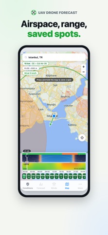
• A time band you can scrub. Drag across the day and watch the verdict, the wind arrow on the map and every tile follow. Sunrise, sunset, stars and the actual moon phase included.

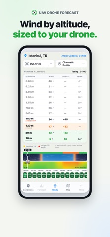
• Wind by altitude. Ground to 120 m in your legal envelope — coloured by your drone's limits — plus the free atmosphere up to 5.6 km for context.

• Real airspace. FAA LAANC grids in the US and worldwide zones from a community-maintained open aviation database, drawn on a fast vector map with your drone's transmission range and visual line-of-sight rings. Zones that can't affect a drone at 120 m are shown as advisory instead of painting your whole city red.

• Save your spots. Long-press the map to save a launch site; every saved pin shows its own live verdict, so the map answers "where can I fly today?"

• Visible satellites, computed for real. GPS + Galileo + BeiDou counts from live orbital data — not a hardcoded guess.

• Quality vs safety, separated. Gusty air that would shake cinematic footage is a warning, not a fake no-go. Darkness is advice ("obstacle sensors may not work"), never a veto. The no-go line is your aircraft's physics.

• Find yourself instantly. Open the app and it centres on where you stand (with your permission) — or search any place on Earth.

No account, no ads.

Data: Open-Meteo, NOAA (METAR/TAF, Kp), CelesTrak, FAA UAS Facility Maps, open aviation data (CC BY-NC 4.0), OpenFreeMap © OpenStreetMap contributors.

Weather and airspace data are not certified for flight planning. Always check your national aviation authority and NOTAMs before every flight.
